New Jersey Property Fax
Flood Determination
What a Flood Search means to you.
Looking for a new home can be both stressful and exciting at the same time. There are many aspects to consider after finding that potential dream home, not least of which should be determining the risk of flooding. Everyone lives in a flood zone–it's just a question of whether you live in a low, moderate, or high risk area.
Purchasing a home in a high risk Flood area can add thousands of dollars in insurance premiums per year, not to mention the heartache and aggravation incurred by damage to property and belongings should flooding occur.
NJ Property Fax offers a simple cost effective way of ensuring that you are informed about the risk of flooding on a property. Hours of time and money can be saved by Real Estate Professionals, home buyers and sellers by performing a Flood Search.
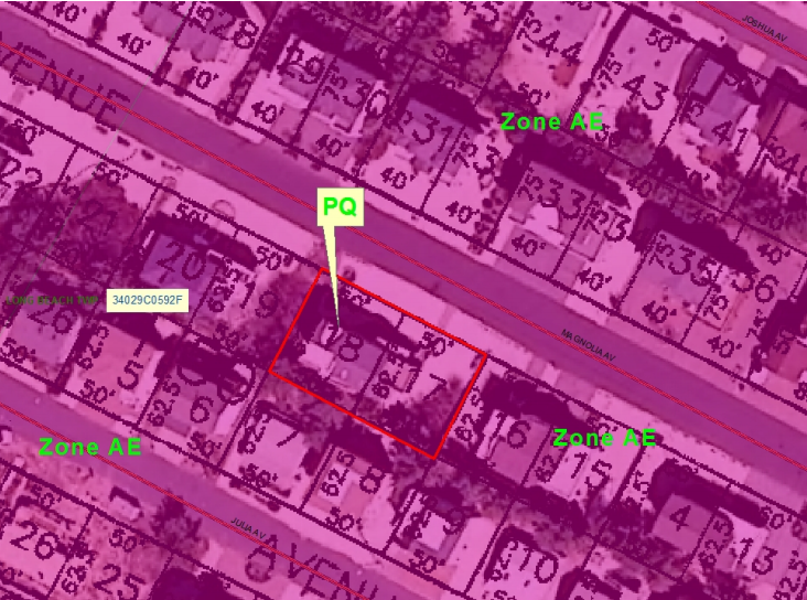
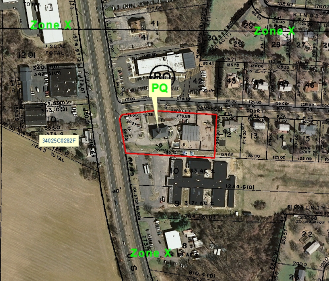
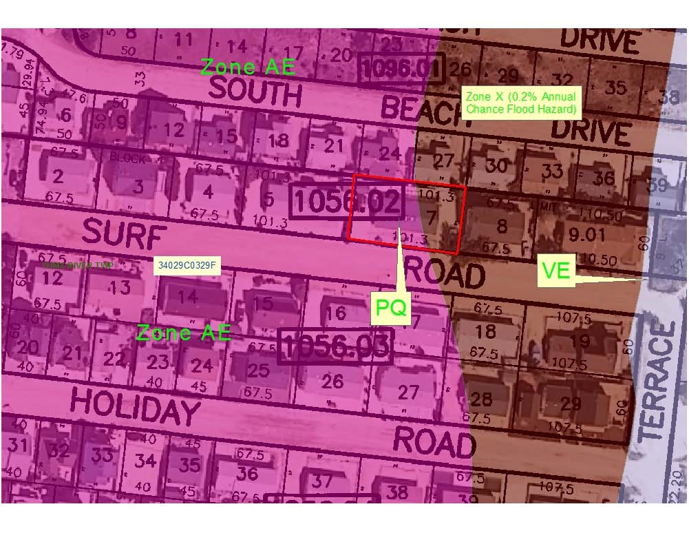
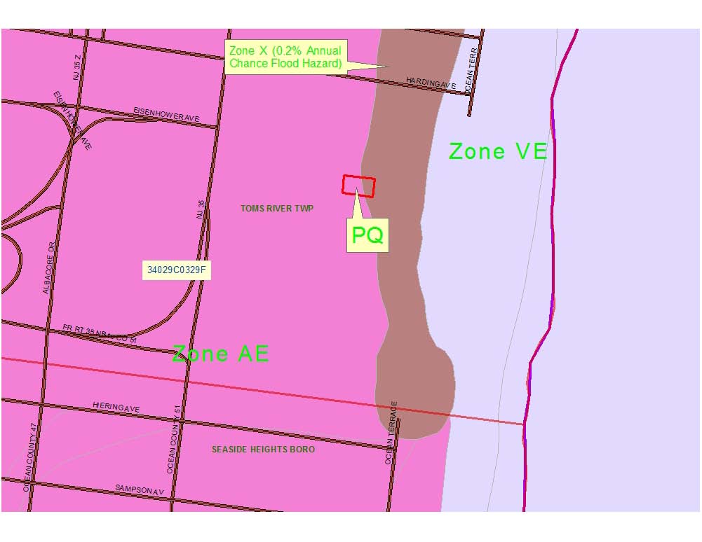
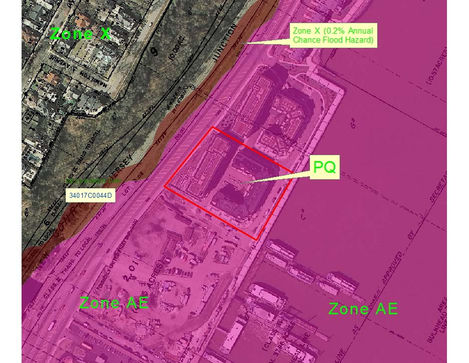
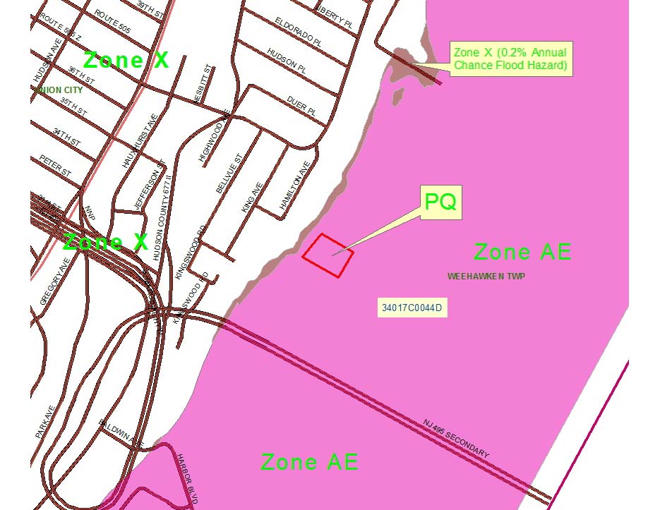
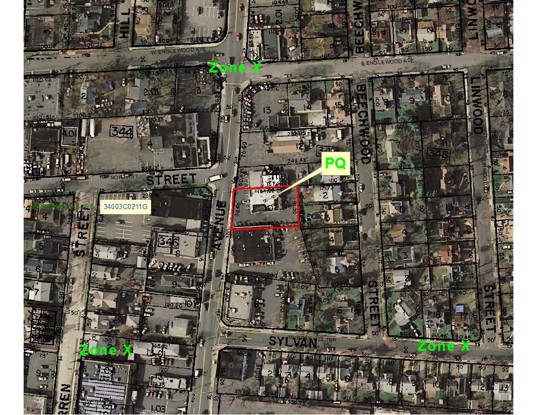
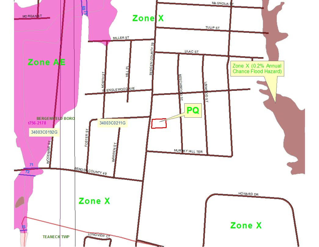
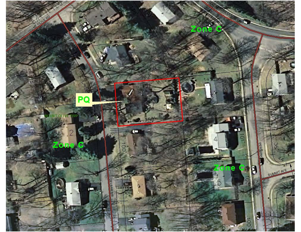
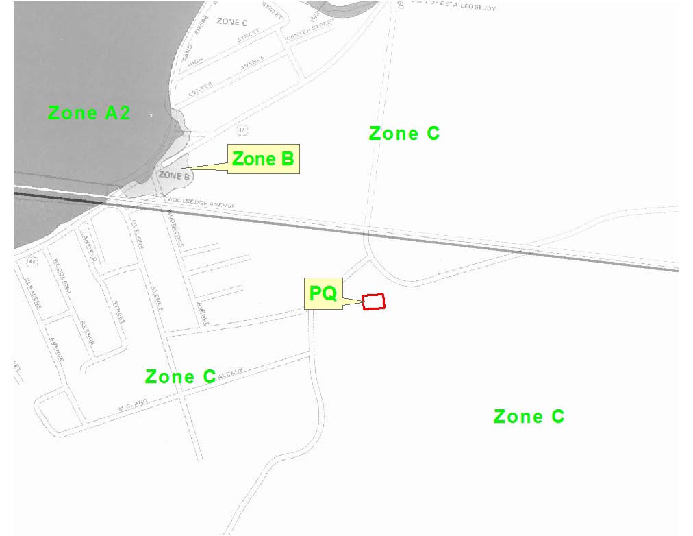
A Flood search is a comprehensive analysis of structures and property boundaries to determine which Flood zones may apply. A report in PDF form is emailed to you within 24 hours; most reports are completed within a few hours. The report consists of the following map overlays:
- Property Boundaries
- Aerial Photography
- Street Maps
- FEMA Flood Zones
Using the latest GIS (Geographic Information System) technology and most currently available information from FEMA (Federal Emergency Management Agency) NJPF will provide a complete, fully insured report on the selected property.
Flood Determination - Questions and Answers (show/hide all)
-
About the National Flood Insurance Program
Since standard homeowners insurance doesn't cover flooding, it's important to have protection from the floods associated with hurricanes, tropical storms, heavy rains and other conditions that impact the U.S.
In 1968, Congress created the National Flood Insurance Program (NFIP) to help provide a means for property owners to financially protect themselves. The NFIP offers flood insurance to homeowners, renters, and business owners if their community participates in the NFIP. Participating communities agree to adopt and enforce ordinances that meet or exceed FEMA requirements to reduce the risk of flooding.
-
What are Flood Zones?
Flood zones are land areas identified by the Federal Emergency Management Agency (FEMA). Each flood zone describes that land area in terms of its risk of flooding. Everyone lives in a flood zone–it's just a question of whether you live in a low, moderate, or high risk area.
-
What constitutes a high risk flood area?
High risk flood areas are known as SFHAs (Special Flood Hazard Areas)
Over the course of a 30 year mortgage, properties in a SFHA have a 26% chance of flooding at least once over the course of the loan.
-
Which Flood Zones REQUIRE me to get Flood Insurance?
Any structures on a property which fall inside SFHA zone A or V are required to get Flood insurance.
- EACH structure inside the SFHA is required to have its own separate flood insurance policy.
- ONLY structures are required to get flood insurance, if portions of the property are within a SFHA, but no structures are, flood insurance is NOT required.
-
What is a Non-Special Flood Hazard Area (NSFHA)?
A Non-Special Flood Hazard Area (NSFHA) is an area that is in a moderate-to-low risk flood zone (Zones B, C, X Pre- and Post-FIRM). An NSFHA is not in any immediate danger from flooding caused by overflowing rivers or hard rains.
However, it’s important to note that structures within a NSFHA are still at risk. In fact, one out of four floods occurs in an NSFHA!
Flood Zone Legend:
The 1% annual flood (100 year flood), also known as the base flood, is the flood that has a 1% chance of being equaled or exceeded in any given year.
The Special Flood Hazard Area is the area subject to flooding by the 1% annual chance flood. Areas of Special Flood Hazard include Zones A, AE, AH, AO, AR, A99, V, and VE.
The Base Flood Elevation is the water-surface elevation of the 1% annual flood.
SFHAs (Special Flood Hazard Area designated zones)
- Zone A – No Base Flood Elevations determined.
- Zone AE – Base Flood Elevations determined.
- Zone AH – Flood depths of 1 to 3 feet (usually areas of ponding); Base Flood Elevations determined.
- Zone AO – Flood Depths of 1 to 3 feet (usually sheet flow on sloping terrain); average depths determined. For areas of alluvial fan flooding, velocities also determined.
- Zone AR – Special Flood Hazard Area formerly protected from the 1% annual chance flood by a flood control system that was subsequently decertified. Zone AR indicates that the former flood control system is being restored to provide protection from the 1% annual chance or greater flood.
- Zone A99 – Area to be protected from 1% annual chance flood by a Federal flood protection system under construction; no Base Flood Elevations determined.
- Zone V – Coastal flood zone with velocity (wave action); no Base Flood Elevations determined.
- Zone VE – Coastal flood zone with velocity hazard (wave action); Base Flood Elevations determined.
-
OTHER (Zones which are NOT designated as Special Flood Hazard Areas)
- X (0.2 percent annual chance) – Areas of 0.2% annual chance flood; areas of 1% annual chance flood with average depths of less than 1 foot or with drainage areas less than 1 square mile; and areas protected by levees from 1% annual chance flood.
- X – Areas determined to be outside the 0.2% annual chance floodplain.
- D – Areas in which flood hazards are undetermined, but possible.
- C – Areas of minimal flooding.
-
What if I don’t believe my property is in a SFHA, can I dispute it?
Yes you can. Have a professional engineer or surveyor produce A Flood Elevation Certificate.
A structure with a properly completed Elevation Certificate may qualify for a discount on flood insurance premiums. The structure or property can be removed from a SFHA with a Letter Of Map Amendment (LOMA).
-
What is a Flood Elevation Certificate?
A Flood Elevation Certificate is a document generated by an engineer, or surveyor, that can determine where precisely your home is located in relationship to the Base Flood Elevation. The Flood Elevation Certificate is a tool that FEMA uses to certify building elevations, and if the building is located in a Special Flood Hazard Area.
-
What is a LOMA?
If you believe your property is not located in the designated 100-year floodplain [also known as a 1-percent-annual-chance floodplain, or Special Flood Hazard Area (SFHA)], as shown on the effective Flood Insurance Rate Map or Digital Flood Insurance Rate Map for your community and you would like the Federal Emergency Management Agency (FEMA) to make an official determination regarding the location of your property relative to the SFHA, you may request a Letter of Map Amendment (LOMA) or a Letter of Map Revision Based on Fill (LOMR-F).
You can request removal of a property and/or structure from the SFHA, for a single residential lot or structure (MT-EZ), and for requests involving multiple residential lots or structures and for all LOMR-F requests (MT-1).
State‐of‐the‐Art Technology
GIS ‐ Geographic Information SystemsA Geographic Information System (GIS) integrates hardware, software, and data for capturing, managing, analyzing, and displaying all forms of geographically referenced information. GIS allows us to view, understand question, interpret, and visualize data in many ways that reveal relationships, patterns, and trends in the form of maps, globes, reports, and charts.
NJ Property Fax has all its Tidelands searches performed by Western Technologies Group, LLC. Western Technologies Group, LLC. is a New Jersey mapping company leveraging 20 years of mapping experience, collections of parcel mapping, tax maps, filed sub-division maps and engineering drawings to identify, in real space, property boundaries in New Jersey. This geographic data helps WTG make accurate, timely and informed decisions. WTG is a leader in Tidelands and Flood Searches for hundreds of Title companies, banks, mortgage companies and Real Property professionals in the US.